Selectmen wary of Hurricane Joaquin as forecasts put storm out to sea
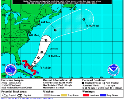
New forecasts from the National Weather Service put the path of Hurricane Joaquin far away from the South Coast by Tuesday morning, but Marion Selectmen and public safety officials are keeping an eye on the Category 4 storm, which could still change course.
Selectmen held an emergency meeting Friday morning when initial forecasts put the storm on track to make landfall in Long Island and Connecticut early Tuesday.
Police Chief Lincoln Miller told the board about the change in path on a stormy morning that featured rain, fog and wind unrelated to the hurricane.
“Today things are looking much better,” Miller said. “The forecast tracks the storm well out to sea.”
On Thursday, Miller and other department heads met to discuss storm preparations. He said the town should remain cautious.
“I think we still have to be aware that things could change. [Forecasters] don’t like to predict much beyond a certain path 48 hours before,” Miller said. “We certainly will keep an eye on it.”
The storm is currently lashing the Bahamas with rain and sustained winds of 130 mph. Later on Friday, Joaquin is expected to head north and weaken into Saturday.
The National Weather Service’s forecast originally had the storm moving closer to the East Coast that had already experienced flooding and heavy rain, including the tri-town.
Even if the hurricane moves further into the Atlantic, Dawson said there’s still a chance for heavy rain.
“It’s very uncertain at this point,” he said.
After the update, the board voted to make Chair Stephen Cushing as the point of contact for emergency operations should that become necessary.
The role would require Cushing to authorize storm related expenditures, field calls and be present at the emergency operation center.


