Cove controversy: Boaters speak against Wings Cove pier
MARION — Tempers flared at a Sept. 20 Planning Board meeting when several residents voiced concern about an in-construction pier in Wings Cove.
Residents have been speaking out about the pier since it began construction in August, claiming the structure would impede boaters’ ability to navigate from the cove’s boat ramp out into Buzzards Bay.
While plans for the pier and an attached floating dock were approved at a Planning Board meeting last March, frequent users of the cove feel the board was misled by a project engineer.
“There was just a very large misrepresentation by the engineer,” Katherine Hoyt said.
At that March meeting, Hoyt explained, an engineer said the pier would jut no further into the cove than other docks. She and other users of the cove say that the pier would not only jut further into the cove, but also impede navigation far more than any of the cove’s other docks.
While the pier’s owner Michael Vareika scaled the project back by 30 feet after an initial outpouring of Facebook posts by users of the cove last month, boaters at the Sept. 20 meeting were in search of further alterations to aid navigation.
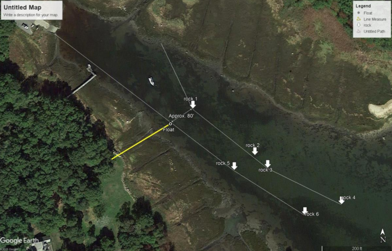
Boaters claim the pier at its currently planned length — jutting about 50 feet into the cove — would cross over part of a channel they say is vital to navigation in the cove. According to some boaters, a number of large rocks in the north side of the cove make navigation outside the channel impossible.
“There’s no way I could get past that dock the way it was presented in the plan,” said marine engineer and user of the cove Chris Madden. “I’ve lost two propellers in that area in the past four years.”
Some town officials, however, don’t believe the pier will be a problem for boaters.
In a report from Harbormaster Isaac Perry released on Sept. 20, he claims the pier would have little to no effect on navigation through the cove — echoing a recommendation he gave the Planning Board before the project was approved in March.
“Our findings confirmed our initial assessment was accurate;” read the Harbormaster’s report, “this project with reduced length will have little to no impact on navigation to and from the Wings Cove boat ramp.”
The report also claims that any channel that was once present in the cove has long since ceased to exist, despite boaters’ references to and reliance on such a waterway.
“I would also like to make it clear that this is a very shallow area, with a [mean low water] depth of two feet,” the report read. “Uniform bottom contours indicate that any previous channel no longer exists.”
Perry did not speak on the issue at the meeting, but board member Norm Hills echoed the findings of his report to boaters.
“As far as saying there was a channel, there may have been something in 1958,” Hills said. “But it’s not there anymore.”
Perry’s report also identifies six rocks in the cove, mapped on a satellite view of the cove. The map indicates that there is about 80 feet of water between the pier and the rock closest to it, and about as much space between other rocks further east in the cove.
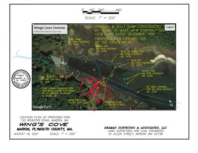
A similar map created by Robert Braman, a surveyor and frequent user of the cove, however, indicates that there exists a much higher volume of rocks impeding navigation in the cove. The map also shows the location of the cove’s controversial channel.
“I have seen boaters come and go for years and years and years,” boater Peter McManmon said. “And if you don’t hug the right side, there are rocks — regardless of the Harbormaster’s technology.”
As comments became heated and board members and residents began talking over one another, member Eileen Marum took the floor. She noted that the project’s March public hearing was advertised as legally required, and all abutters were notified.
But boaters at the meeting begged to differ.
“Respectfully, not all the abutters were notified,” Hoyt said.
More residents began to chime in, noting abutters they claimed were not notified of the March meeting.
Some noted that Piney Point residents were not notified, and one resident chimed in on the meeting’s live chat: “64 Delano Road was not notified.”
The meeting continued to devolve, with some residents taking issue when the board attempted to move on from the discussion.
“We have an unprecedented amount of public [participants] on this meeting right now and you have given us five minutes,” Burke said, referring to a soft time limit Marum put on the discussion before its opening.
Hills and board member Jon Henry noted that the end of a regular meeting of the board was no time for an in-depth discussion on the issue.
“We can go further but it has to be at a scheduled meeting for the discussion,” Hills said.
After some further comment and argument by boaters, Chris Madden took charge to agree to formally submit a request for discussion at the Planning Board’s Oct. 4 meeting.
“If in any way we could regroup, that would be wonderful,” he said.
On the pier’s status until then, Hills said “they can do construction on the dock as long as it’s not in the water.”


