Report: sea level rise poses risk for Marion, Mattapoisett
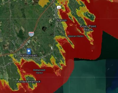
As soon as 2050, Marion and Mattapoisett could see daily coastal flooding, impacting 156 buildings and 3.5 miles of roads in the two towns.
According to a report released by the Trustees of Reservations, a non-profit that works to conserve 27,000 miles of coastlines across the state, coastal communities along Buzzards Bay could see disastrous effects of sea-level rise in the next 30 years.
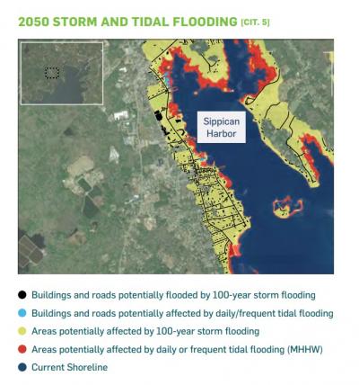
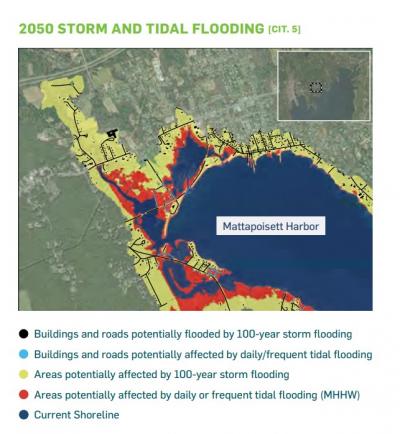
In Mattapoisett, daily tidal flooding could impact 111 buildings and three miles of roads, according to the report. In Marion, daily tidal flooding could affect 45 buildings and a half-mile of roads.
The report went on to say that a 10-year flood could impact 1,142 buildings in Mattapoisett and 890 buildings in Marion by 2050, including homes, businesses and government buildings.
Mattapoisett’s Ned’s Point Lighthouse, Center School and Town Hall, as well as Marion’s Town Landing, Sippican School and Tabor Academy could all be affected by this flooding, said the report.
In Mattapoisett, homes along Molly’s Cove Road, Mattapoisett Neck Road, Holly Woods Road, Angelica Avenue, Brant Island Road, and Aucoot Road are at risk of flooding, according to the report.
In Marion, buildings and homes along Front Street, Route 6, and the Aucoot Cove area are at risk of flooding.
However, both coastal towns are doing what they can to mitigate the effects of sea level rise and coastal flooding, as predicted by the report.
In Mattapoisett, the town is conducting studies on coastal roadways to see how it can make them more resistant to flooding, said Town Administrator Michael Lorenco.
He added that the Long Wharf redesign project, which looks to repair the aging structure, could protect boats and other inner-harbor wharves.
“We can plan for things like coastal storms, but no one knows where or when they will occur,” said Lorenco. “I think it is safe to assume that consequences could be severe with a severe coastal event, with roads becoming unpassable and significant property damage.”
Meanwhile, Marion is looking to build a new harbormaster facility and a new sewer pump station to help protect the town from coastal flooding, said Town Administrator James McGrail.
Marion’s 2021 Hazard Mitigation Plan also outlines several steps the town can take to reduce the impact of coastal flooding.
These steps include educating the public about natural disasters and other hazards, involving local non-profit organizations and businesses in hazard mitigation, and investing in structural improvements to protect vulnerable areas of the town.
According to Marion Select Board Member Norman Hills, the Tri-town has seen its fair share of flooding in the past.
“Historically, the ‘38 hurricane flooded across Route 6 in some places and made a mess downtown,” he said. “You probably could have bought houses pretty cheaply on Water Street after that hurricane.”


