Study considers safety on Route 6
The draft of regional planners’ final report on a months-long study of Route 6 problems and potential solutions recommends a long list of specific improvements. But it takes no position on a possible reconfiguration of the state highway from Fairhaven to Wareham.
The study project, undertaken by the Southeastern Regional Planning and Economic Development District, looked at 13 miles of Route 6 with an eye to improving safety for motorists, pedestrians and cyclists.
At two public hearings this winter, planners sought feedback on a variety of options for reconfiguring Route 6 to accomplish all those goals. Options included reducing the four-lane road to two lanes, adding designated bicycle lanes in the roadway or expanding sidewalks.
The limited and contradictory feedback on reconfiguration prompted planners to recommend that the towns work directly with the Massachusetts Department of Transportation on the matter.
The report, however, makes specific recommendations on safety improvements in certain locations, and recommends additional streetlights, the reconstruction of some intersections, a switch to LED streetlights and drainage improvements.
Before finalizing the report, SRPEDD representatives plan to present their findings to selectmen in the four affected towns, beginning with Marion Selectmen at 7 p.m. on Tuesday, March 3.
The draft report, released on Feb. 19, calls Route 6 an “auto-centric 4-lane highway that prioritizes vehicle use and discourages walking or biking.”
The planner recommended that the towns and state:
- — add a signal at Spring Street in Marion
- — modify lights at Front Street in Marion and North Street in Mattapoisett to include a left turn lane and signal
The towns should also change intersections to 90 degree angles at
- — Brandt Island Road in Mattapoisett
- — Church Street Extension in Mattapoisett
- — Converse Road in Marion
- — Creek Road in Marion
Other general recommendations included using more visible signage, adding LED streetlights, making crosswalk markings more visible, reconstructing drainage to avoid standing water, removing telephone poles from sidewalks to make them handicap accessible, and adding bicycle signage.
The study suggested that these changes be made whether or not Route 6 changes in its configuration.
The study’s authors looked to come to more of a consensus on how residents in all towns would like to see Route 6 changed, and to judge whether residents would favor a two lane highway. The planning study will also serve as an important tool for the towns as they move forward in talking with the state about any changes.
Cornock had previously presented four options for the road, but rather that choosing one for all 13 miles, wanted to leave it to the towns because they had “a mix of responses. There isn’t a clear consensus about the entire corridor,” said Jed Cornock, the project’s contact with SRPEDD.
He added that some communities feel more passionately about one option or the other, and should contact the state Department of Transportation to make that happen.
To brainstorm new configurations for the road, SRPEDD looked at 32 diagrams completed at informational meetings. Three layouts that had the most consensus and were advanced to Phase 2 of the study.
Meeting attendees preferred a three lane configuration early on, but SRPEDD did not include this option because of safety concerns. Based on state design guides, three lane configurations should have a speed limit of 30 mph, but even the lower end of the range of average speeds observed on Rte. 6 clocked in at 36 miles an hour.
Regarding the three lane option, the planner said, “Mass DOT should work closely with the communities to determine if a solution can be engineered.”
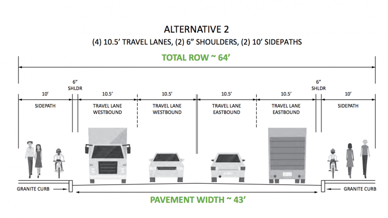
Of the four alternatives that the group presented this winter, the group said “The majority of respondents preferred Alternative #2 — keeping the 4-lane configuration while expanding the existing sidewalks to provide a 10-foot sidepath on both sides of the road for the entire corridor.”
That majority would be 31% of 113 preference surveys. However, the study authors expressed some concern with that option because it does not address high speeds on the road or narrow travel lanes and would require buying land.
SRPEDD will be accepting comments on the draft study until March 17, 2020. Comments can be emailed to: jcornock@srpedd.org.


